e99 Online Shopping Mall

Geometry.Net - the online learning center Help  
Home  - Science - Geomatics (Books)

  Back | 21-40 of 91 | Next 20
A  B  C  D  E  F  G  H  I  J  K  L  M  N  O  P  Q  R  S  T  U  V  W  X  Y  Z  

click price to see details     click image to enlarge     click link to go to the store

$29.95
21. The Nova Scotia Atlas
 
$5.95
22. Geomatics on the cutting edge
$8.95
23. Towards operational monitoring
$8.95
24. Estimation of disaggregated canal
 
$5.95
25. Letter from the editor.(geomatics
 
26. Fundamentals of Geomatics (Integrating
 
$5.95
27. Mississippi -- the new leader
 
$5.95
28. Mississippi geomatics conference
$7.95
29. Modeling and analysis of a Canadian
 
30. Real Property Issues in the Marine
$14.13
31. Entreprise Informatique Canadienne:
 
32. Geomatics (Sector competitiveness
 
33. Geomatics - 2003 publication
$215.00
34. ISO/TR 19122:2004, Geographic
 
$24.25
35. Least Squares Spectral Analysis
 
$139.00
36. Elem Surveying: Intro Geomatics&
 
37. Modeling in Resource Management
 
$9.95
38. Business geomatics: a burgeoning
$10.95
39. A geomatics-based road surface
 
$75.64
40. English-Chinese/Chinese-English

21. The Nova Scotia Atlas
by Service Nova Scotia and Municipal Relations Nova Scotia Geomatics Centre
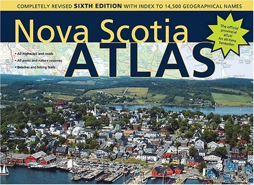
Spiral-bound: 144 Pages (2006-06-16)
list price: US$29.95 -- used & new: US$29.95
(price subject to change: see help)
Asin: 0887807070
Canada | United Kingdom | Germany | France | Japan
Editorial Review

Product Description
This sixth edition of the Nova Scotia Atlas provides in-depth coverage of the entire province unavailable anywhere else. The maps include numbered and colour-coded highways with exit numbers, hiking trails and national parks. There are details such as power lines, ferry routes, hospitals and communication towers. Airports, helipads and landing strips are mapped. Also included are all provincial parks (campgrounds, picnic sites, boat launches), with a text description of each. The maps clearly show physical features, including rivers, lakes, hills, islands, marshes and beaches.
The revisions in this new edition include all new highway construction completed in the past five years, three new wildernessareas and six new nature reserves. Waterfalls are now shown, and Crown land information has been extensively updated. All paved and unpaved roads (longer than 200 m) are included, as are a myriad of protected areas including game sanctuaries, wilderness and wildlife management areas. County and municipal boundaries are shown. ... Read more


22. Geomatics on the cutting edge of information-age technology. (Resources Reports): An article from: Northern Ontario Business
by Joan Campbell
 Digital: 3 Pages (1992-10-01)
list price: US$5.95 -- used & new: US$5.95
(price subject to change: see help)
Asin: B00092JZFA
Canada | United Kingdom | Germany | France | Japan
Editorial Review

Product Description
This digital document is an article from Northern Ontario Business, published by Laurentian Business Publishing, Inc. on October 1, 1992. The length of the article is 881 words. The page length shown above is based on a typical 300-word page. The article is delivered in HTML format and is available in your Amazon.com Digital Locker immediately after purchase. You can view it with any web browser.

Citation Details
Title: Geomatics on the cutting edge of information-age technology. (Resources Reports)
Author: Joan Campbell
Publication: Northern Ontario Business (Magazine/Journal)
Date: October 1, 1992
Publisher: Laurentian Business Publishing, Inc.
Volume: v13Issue: n1Page: p27(1)

Distributed by Thomson Gale ... Read more


23. Towards operational monitoring of a northern wetland using geomatics-based techniques [An article from: Remote Sensing of Environment]
by J. Toyra, A. Pietroniro
Digital: Pages
list price: US$8.95 -- used & new: US$8.95
(price subject to change: see help)
Asin: B000RR6RAS
Canada | United Kingdom | Germany | France | Japan
Editorial Review

Product Description
This digital document is a journal article from Remote Sensing of Environment, published by Elsevier in . The article is delivered in HTML format and is available in your Amazon.com Media Library immediately after purchase. You can view it with any web browser.

Description:
This paper presents a geomatics-based approach for the operational monitoring of spatio-temporal changes in a northern wetland. It demonstrates how valuable, and otherwise unattainable, spatially distributed and timely baseline data can be obtained using basic remote sensing techniques. It further shows how these data can be combined to retrieve information pertaining to the hydro-ecological relationships in the wetland. The study was conducted in the Peace-Athabasca Delta (PAD), which is a large wetland complex in northeastern Alberta, Canada. Combinations of Radarsat Synthetic Aperture Radar (SAR) and optical satellite images (Landsat or SPOT multispectral) were used to generate a time-series of flood maps for the six-year period, 1996 to 2001. These maps clearly depict the extent of the 1996 and 1997 overland floods and the subsequent water level draw down. A flood duration map that shows how long each image cell was inundated was generated by combining the series of flood maps. The flood duration map highlights regions where the duration of flooding appears to be highest or lowest. Such maps are invaluable for any ecological change detection protocols that may be developed for this region. The general vegetation patterns were also mapped using multi-temporal SPOT-4 images from the summer season (May and August) of 2001 to an accuracy of 86%. By comparing the vegetation and flood duration maps, the relationship between vegetation patterns and duration of flooding could be examined. Results indicated that basins inundated for longer periods (3-5 years) were dominated by relatively more productive graminoid (grass-like) vegetation, whereas, areas flooded for less than two years were characterised by less productive shrub vegetation. Airborne scanning LiDAR (Light Detection and Ranging) data from the summer (June) of 2000 were also used to generate a Digital Elevation Model (DEM) of selected non-flooded areas. LiDAR DEM accuracy was satisfactory (Root Mean Square Error of 0.24 m) and it proved to be sufficiently detailed to detect the subtle topographic patterns in this relatively flat region. Comparison of the vegetation map to the DEM demonstrated that the shrubs were located in areas that were, on average, between 0.5 m (in south) and 0.73 m (in north) higher than the graminoid covered regions. Notwithstanding other parameters that influence the distribution of vegetation, these results indicate that flood duration and elevation are two important factors. The usefulness of these spatial databases recommends the timely generation of flood and vegetation maps in the continued monitoring of the changes and relationships in this delta. ... Read more


24. Estimation of disaggregated canal water deliveries in Pakistan using geomatics [An article from: International Journal of Applied Earth Observations and Geoinformation]
by M.u.D. Ahmad, A. Stein, W.G.M. Bastiaanssen
Digital: Pages (2004-11-01)
list price: US$8.95 -- used & new: US$8.95
(price subject to change: see help)
Asin: B000RR0OVQ
Canada | United Kingdom | Germany | France | Japan
Editorial Review

Product Description
This digital document is a journal article from International Journal of Applied Earth Observations and Geoinformation, published by Elsevier in 2004. The article is delivered in HTML format and is available in your Amazon.com Media Library immediately after purchase. You can view it with any web browser.

Description:
Lack of accurate information on water distribution within an irrigation system is a major roadblock for effective management of scarce water resources. Numerical techniques to estimate canal water distribution require large amounts of data with respect to hydraulic parameters and operation of the hydraulic structures; such data are absent in large irrigation systems. In this study, six quantitative geomatic models, with varying complexity and physical representation, were formulated. They all use high-spatial resolution Landsat-7 images and a canal network stored in a GIS. The models require only the flow rates at the head of the distribution system to calculate downstream water distribution. Results were compared with discharge measurements for three tertiary canals (watercourses) within two selected secondary canals (distributaries), Gajiana and Ghour Dour, in Rechna Doab, Pakistan. The model that computed canal water distribution using the shape of the irrigated area was the most accurate at the watercourse scale. The overall deviation was 28% and the standard deviation of differences between modelled and measured flow was 10%. The model that relates canal water distribution directly to normalized difference vegetation index (NDVI) has the lowest accuracy with a 32% absolute deviation and 16% standard deviation. We conclude that geo-information techniques can be used to compute water distribution in large irrigation systems with a minimum of field data if an appropriate geomatic model is selected. ... Read more


25. Letter from the editor.(geomatics in retail and business)(Editorial): An article from: Canadian Journal of Regional Science
 Digital: 2 Pages (2001-09-22)
list price: US$5.95 -- used & new: US$5.95
(price subject to change: see help)
Asin: B0008IQ8T6
Canada | United Kingdom | Germany | France | Japan
Editorial Review

Product Description
This digital document is an article from Canadian Journal of Regional Science, published by Canadian Journal of Regional Science on September 22, 2001. The length of the article is 533 words. The page length shown above is based on a typical 300-word page. The article is delivered in HTML format and is available in your Amazon.com Digital Locker immediately after purchase. You can view it with any web browser.

Citation Details
Title: Letter from the editor.(geomatics in retail and business)(Editorial)
Publication: Canadian Journal of Regional Science (Refereed)
Date: September 22, 2001
Publisher: Canadian Journal of Regional Science
Volume: 24Issue: 3Page: 373(2)

Article Type: Editorial

Distributed by Thomson Gale ... Read more


26. Fundamentals of Geomatics (Integrating Geographic Information Systems, Remote Sensing, Global Positioning Systems, and Infomatics)
by Scott Madry
 Spiral-bound: Pages (1996)

Asin: B000BU49YC
Canada | United Kingdom | Germany | France | Japan

27. Mississippi -- the new leader in geomatics? (Focus: Economic Development).(Brief Article): An article from: Mississippi Business Journal
by Elizabeth Kirkland
 Digital: 4 Pages (2002-05-06)
list price: US$5.95 -- used & new: US$5.95
(price subject to change: see help)
Asin: B0008FBRCW
Canada | United Kingdom | Germany | France | Japan
Editorial Review

Product Description
This digital document is an article from Mississippi Business Journal, published by Venture Publications on May 6, 2002. The length of the article is 967 words. The page length shown above is based on a typical 300-word page. The article is delivered in HTML format and is available in your Amazon.com Digital Locker immediately after purchase. You can view it with any web browser.

Citation Details
Title: Mississippi -- the new leader in geomatics? (Focus: Economic Development).(Brief Article)
Author: Elizabeth Kirkland
Publication: Mississippi Business Journal (Magazine/Journal)
Date: May 6, 2002
Publisher: Venture Publications
Volume: 24Issue: 18Page: 20(2)

Article Type: Brief Article

Distributed by Thomson Gale ... Read more


28. Mississippi geomatics conference draws high-tech crowd.(Focus Tech Report 1.4): An article from: Mississippi Business Journal
by Lynn W. Jeter
 Digital: 4 Pages (2003-09-08)
list price: US$5.95 -- used & new: US$5.95
(price subject to change: see help)
Asin: B0008E412G
Canada | United Kingdom | Germany | France | Japan
Editorial Review

Product Description
This digital document is an article from Mississippi Business Journal, published by Venture Publications on September 8, 2003. The length of the article is 1036 words. The page length shown above is based on a typical 300-word page. The article is delivered in HTML format and is available in your Amazon.com Digital Locker immediately after purchase. You can view it with any web browser.

Citation Details
Title: Mississippi geomatics conference draws high-tech crowd.(Focus Tech Report 1.4)
Author: Lynn W. Jeter
Publication: Mississippi Business Journal (Magazine/Journal)
Date: September 8, 2003
Publisher: Venture Publications
Volume: 25Issue: 36Page: 23(1)

Distributed by Thomson Gale ... Read more


29. Modeling and analysis of a Canadian Forces Geomatics division workflow [An article from: European Journal of Operational Research]
by A. Ghanmi
Digital: 15 Pages (2006-05-01)
list price: US$7.95 -- used & new: US$7.95
(price subject to change: see help)
Asin: B000RR9URU
Canada | United Kingdom | Germany | France | Japan
Editorial Review

Product Description
This digital document is a journal article from European Journal of Operational Research, published by Elsevier in 2006. The article is delivered in HTML format and is available in your Amazon.com Media Library immediately after purchase. You can view it with any web browser.

Description:
This paper addresses workflow issues of a Geomatics division in the Canadian Forces. This division is dedicated to the production of Geomatics Information under the US National Geospatial-Intelligence Agency's Foundation Based Operations concept. This paper outlines a methodology for modeling and analyzing the workflow of the Canadian Forces Geomatics division. A discrete event simulation model is developed and applied to measure the performance of the workflow system for developing Geomatics products. A hybrid queueing network/optimization model is also developed to support the simulation model. The objective of the queueing network/optimization formulation is to provide the optimal configuration of the Geomatics division. The paper successfully addresses a complex workflow problem in the context of real world system and provides insights into the performance of the Canadian Forces Geomatics processing. ... Read more


30. Real Property Issues in the Marine Aquaculture Industry in New Brunswick (UNB Geodesy and Geomatics Enginering Technical Report, No. 208)
 Paperback: Pages (2001)

Asin: B000HDDQ2O
Canada | United Kingdom | Germany | France | Japan

31. Entreprise Informatique Canadienne: Netgraphe, Canoë, Cognos, Dbx Geomatics, Certicom, Mamma.com (French Edition)
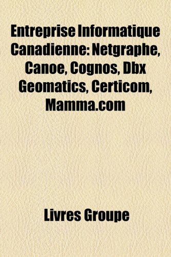
Paperback: 24 Pages (2010-07-28)
list price: US$14.14 -- used & new: US$14.13
(price subject to change: see help)
Asin: 115946278X
Canada | United Kingdom | Germany | France | Japan
Editorial Review

Product Description
Les achats comprennent une adhésion à l'essai gratuite au club de livres de l'éditeur, dans lequel vous pouvez choisir parmi plus d'un million d'ouvrages, sans frais. Le livre consiste d'articles Wikipedia sur : Netgraphe, Canoë, Cognos, Dbx Geomatics, Certicom, Mamma.com. Non illustré. Mises à jour gratuites en ligne. Extrait : Netgraphe, compagnie québécoise fondée en 1996, était la plus importante entreprise d'édition francophone sur Internet au Canada à la fin des années 1990 et au début des années 2000. Le 30 septembre 1999, Netgraphe inc. est devenue la première entreprise Internet publique cotée à la Bourse de Montréal. Quebecor ayant pris le contrôle de la compagnie, toutes ses activités furent fusionnées avec celles du portail Internet Canoe.ca et le nom de Netgraphe fut abandonné en 2005. Ayant son siège social à Montréal, Netgraphe exerçait ses activités dans le secteur de l'édition sur Internet au Canada. La compagnie se spécialisait dans la diffusion de contenu, la publicité, le commerce électronique et les services de conception, de réalisation et de maintenance de sites Internet. À son apogée, elle exploitait, entre autres, les sites populaires suivants : Œuvrant dans la presse écrite, Yves Williams et Chrystian Guy créent le site La toile du Québec en mars 1995. Un passe-temps au début, le site prendra rapidement de plus en plus d'expansion autant en termes de nombre de sites recensés qu'en nombre de visiteurs. Le succès du site pousse les deux créateurs à quitter leur emploi et à s'associer à la compagnie de gestion Pluricom (détenue par Normand Drolet et Marc Copti) pour fonder la compagnie Netgraphe inc. en mai 1996. Bien vite, la compagnie commence à offrir des services de création de site Web. Les années suivantes vont voir la création par Netgraphe de plusieurs sites spécialisés : Comptoir, répertoire de sites québécois faisant du commerce électronique; Mégagiciel, un répertoire de jeux et de logiciels gr...http://booksllc.net/?l=fr ... Read more


32. Geomatics (Sector competitiveness frameworks)
 Unknown Binding: Pages (1997)

Isbn: 0662628616
Canada | United Kingdom | Germany | France | Japan

33. Geomatics - 2003 publication
by BarryFKavanagh
 Hardcover: Pages (2003-01-01)

Asin: B0036HGGCA
Canada | United Kingdom | Germany | France | Japan

34. ISO/TR 19122:2004, Geographic information / Geomatics - Qualification and certification of personnel
by ISO/TC 211
Paperback: 106 Pages (2007-08-23)
list price: US$215.00 -- used & new: US$215.00
(price subject to change: see help)
Asin: B000Y2TZ5U
Canada | United Kingdom | Germany | France | Japan
Editorial Review

Product Description
ISO/TR 19122:2004 is applicable to the following aspects of the field of Geographic Information/Geomatics:To develop a Type 3 report, which describes a system for the qualification and certification, by a central independent body, of personnel in the field of Geographic Information/Geomatics.To define the boundaries between Geographic Information/ Geomatics and other related disciplines and professions.To specify technologies and tasks pertaining to Geographic Information/Geomatics.To establish skill sets and competency levels for technologists, professional staff and management in the field.To research the relationship between this initiative and other similar certification processes performed by existing professional associations.To develop a plan for the accreditation of candidate institutions and programs, for the certification of individuals in the workforce, and for collaboration with other professional bodies. ... Read more


35. Least Squares Spectral Analysis Revisited (UNB Geodesy and Geomatics Engineering Technical Report, No. 84)
 Paperback: Pages (1994)
-- used & new: US$24.25
(price subject to change: see help)
Asin: B000HDBUHW
Canada | United Kingdom | Germany | France | Japan

36. Elem Surveying: Intro Geomatics& 1key CC Pk
 Hardcover: Pages (2005-05)
list price: US$139.00 -- used & new: US$139.00
(price subject to change: see help)
Asin: 0132246783
Canada | United Kingdom | Germany | France | Japan

37. Modeling in Resource Management and Environment Through Geomatics
by P.R. Binda
 Hardcover: 304 Pages (2008-12-01)

Isbn: 8180694879
Canada | United Kingdom | Germany | France | Japan
Editorial Review

Product Description
This book consists of selected lectures delivered by the eminent scientists during this training programme. These lectures cover various aspects of modeling in resource management and environment through remote sensing. Geomatics is an important tool for resource analysis and management of environment. It is hoped that his book will be emmensely useful to the students, teachers, research scholars, geographers adn scientists of cognate discipline who are using remote snesing and geomatic techniques in their research. ... Read more


38. Business geomatics: a burgeoning discipline/La geomatique des affaires : une discipline en plein essor.: An article from: Canadian Journal of Regional Science
by Tony Hernandez
 Digital: 14 Pages (2006-09-22)
list price: US$9.95 -- used & new: US$9.95
(price subject to change: see help)
Asin: B000VJB374
Canada | United Kingdom | Germany | France | Japan
Editorial Review

Product Description
This digital document is an article from Canadian Journal of Regional Science, published by Thomson Gale on September 22, 2006. The length of the article is 3974 words. The page length shown above is based on a typical 300-word page. The article is delivered in HTML format and is available in your Amazon.com Digital Locker immediately after purchase. You can view it with any web browser.

Citation Details
Title: Business geomatics: a burgeoning discipline/La geomatique des affaires : une discipline en plein essor.
Author: Tony Hernandez
Publication: Canadian Journal of Regional Science (Magazine/Journal)
Date: September 22, 2006
Publisher: Thomson Gale
Volume: 29Issue: 3Page: 349(9)

Distributed by Thomson Gale ... Read more


39. A geomatics-based road surface temperature prediction model [An article from: Science of the Total Environment, The]
by L. Chapman, J.E. Thornes
Digital: 12 Pages (2006-05-01)
list price: US$10.95 -- used & new: US$10.95
(price subject to change: see help)
Asin: B000RR9K3Y
Canada | United Kingdom | Germany | France | Japan
Editorial Review

Product Description
This digital document is a journal article from Science of the Total Environment, The, published by Elsevier in 2006. The article is delivered in HTML format and is available in your Amazon.com Media Library immediately after purchase. You can view it with any web browser.

Description:
A GIS-based model for the prediction of road surface temperature is presented that has the ability to explain up to 74% of the spatial variation in road surface temperature in the West Midlands, UK. The approach combines basic spatial data sets with a synergy of surveying techniques to produce a geographical parameter database that drives the spatial component of a road weather prediction model. By measuring and modelling geographical parameters such as altitude, landuse, road construction and the sky-view factor, pre-existing components of road ice prediction systems can be united to provide a dynamic road ice prediction system. ion system. ... Read more


40. English-Chinese/Chinese-English Vocabulary Handbook for Geomatics Engineering
by Editor: Yin Hui
 Paperback: Pages (1991-01-01)
-- used & new: US$75.64
(price subject to change: see help)
Asin: 7307062275
Canada | United Kingdom | Germany | France | Japan

  Back | 21-40 of 91 | Next 20
A  B  C  D  E  F  G  H  I  J  K  L  M  N  O  P  Q  R  S  T  U  V  W  X  Y  Z  

Prices listed on this site are subject to change without notice.
Questions on ordering or shipping? click here for help.

site stats